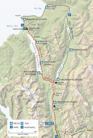
On Monday I set out to complete a 146km loop of the Hollyford Track and Big Bay - Pyke Route in three days. The plan was to be dropped off at 1:00pm on Monday (Day 1) and be picked up on Wednesday (Day 3) at 1:00pm.
The Hollyford is a 56km track that starts at the Lower Hollyford Road and leads to the old port of Martins Bay. The Pyke - Big Bay Route is described as a strenuous route, suitable for experienced and well equipped trampers. Sections of it are prone to flooding and often become impassable in wet weather.
Short version:
I am planning to spend Mon-Wed on the Hollyford Track and Pyke - Big Bay Route.
You should expect to hear from me by 15:30 Wednesday.
Long version:
Monday, December 3
11:00 Bus (Tracknet) Te Anau - Hollyford Road End.
13:00 Run. Hollyford Road End - Hokuri Hut (Hollyford Track). Map attached for reference.
Tuesday, December 4
Run. Hokuri Hut - Martins Bay - Olivine Hut (Pyke - Big Bay Route).
Wednesday, December 5
Run. Olivine Hut - Hollyford Road End.
13:00. Bus (Tracknet) from Hollyford Road End - Te Anau. Due into Te Anau by 15:00.
You should expect to hear from my by 15:30 on Wednesday.
If you have not heard from me by Wednesday 16:30, call:
Tracknet (03) 249 7777
Police / Land SAR 111
I have with me a PLB, survival bag, first aid kit, sleeping bag, food, spare clothing.
Weather. Looks like a bit of rain, and wind. To be expected in Fiordland.
| I carried a personal locator beacon, survival bag, topographical maps, first aid kit, backpack, sleeping bag, spare clothing, food and water. The notable admission being a cooker. You can prepare freeze dried meals with cold water right... I had anticipated covering 8-10km/hr. Owing to a combination of fatigue, pack weight, and the roughness of the track, the 43km on Day 1 from Hollyford Road End to Hokuri Hut took 7 hours at an average speed of just over 6km/hr. My time estimate had gone from 15-18hrs of running over three days to more like 24hrs. In the early hours of Tuesday morning, the promised rain arrived. Not heavy, but persistent. This put a dampener on my spirits, and made the rock based track treacherously slippery further slowing my progress. |
I was carrying a topographical map, as well I have the MapApp SI on my iPhone. The app provides a full topographical map of the South Island as well as a GPS reference point without the need for network coverage. This is a god-send in situations when you need to locate your exact whereabouts on a topographical map, and I was hoping that this would be the ace up my sleeve on the Pyke - Big Bay Route where the track is notoriously difficult to follow. Unfortunately, for reasons I can not explain, I was unable to pick up a reference point. Worse still, by Martins Bay, my waterproof phone case was proving less than waterproof. My trump card was now useless.
Not long after Martins Bay Hut the Track emerges at Long Reef. The home of an ever growing seal colony. Emerge I did, bursting between two harekeke (flax) bushes, only to come face to face with one very large, very angry Fur seal who was not very pleased to see me. There were seals at the bush edge, the waters edge, and not that I could see them until I was upon them, burrowed into the thick bushes. I could barely get onto the point and with wet slippery rocks I definitely wasn’t going to be able to ‘sneak’ nimbly past the seals. There are two rules when encountering seals. Never get between a seal and it’s pup, and never get between a seal and the water. I was now breaking both. I thought that, perhaps if I waited an hour the seals would head for the water, but I didn’t really have an hour to waste.
It was at this point that I was faced the conundrum of whether to try and continue with my original plan. Faced with:
Slower than planned progress.
Being unable to use my trump card.
The challenge of getting safely passed the Long Reef seal colony.
The difficult route ahead.
The rain and therefore increased likelihood of flooding on the Pyke - Big Bay Route.
The lack of alternative options once beyond Big Bay Hut.
1:00pm pickup the following day.
I chose to cut my losses and return the way that I had come with my tail between my legs.
I questioned whether I was just being a coward. Was I in danger? No, though given the above circumstances, had I continued, I suspect that I would have ended up either:
Turning back at Big Bay Hut.
Arriving at Olivine Hut very late (and very very weary) on Day 2.
Missing my 1:00pm pick-up on Day 3.
Back I trudged to Demon Trail Hut. 39km and 8 hours of running (and hiking) for Day 2. Day 3 a mere 32km, 5 hour run (and hike) from Demon Trail Hut back to the Hollyford Road End in time for my 1:00pm pick-up.
In hindsight I think I made the correct decision. I maintain that incidents and accidents generally occur when there are a series of unfortunate events that line up. Retrospectively, it is often easy to see how such events multiply the risk and lead to catastrophe. At the time when you are caught in the emotion of it all, it is difficult to see this happening.
With summer upon us and plenty of adventures being planned. In order to make sure everyone stays safe, I suggest that you dot i's and cross your t's by:
Leaving clear intentions and instructions with multiple parties.
Ensuring you have adequate and appropriate gear for the adventure at hand.
Having an alternative plan and be adaptable.
Knowing your limits.
Taking the emotion out of any/all situations.


